Posted on October 28, 2024
Roleplaying in Averoigne: Map
Averoigne is a dark, weird fantasy setting created by Clark Ashton Smith, one with a troubled history with roleplaying games after the famous Module X2: Castle Amber. This module was produced with the permission of Clark Ashton Smith’s literary estate, and was based heavily on the Averoigne cycle of short stories, poems, and novellas written about or set in the fantastical province of medieval France called Averoigne. The settings of those early modules for the Basic/Expert edition of Dungeons & Dragons became part of the larger Known World setting of B/X then BECMI D&D, by virtue of which, the province of Averoigne is part of Mystara. If you search for a map of Averoigne, you will almost certainly find something informed by if not based on the map of the province in Mystara or X2, and as a map of the D&D version of Averoigne, the one found in Mystara (or in the alternative plane of existence called Laterre) – it’s perfectly serviceable.
As a map of a fantastical province of France, however, it leaves much to be desired. The best specimen “X2” map which can be freely found online is Thorfinn Tait’s excellent version from the equally excellent Atlas of Mystara website. There’s three immediately obvious issues with the map when approaching it from the perspective of wanting it to represent a (realistic) province of medieval France:
- The name Cordeliers should refer to a convent of Conventual Franciscans, or its place. The area in Paris which gave its name to the famous Cordeliers Club of the French Revolution had that name because it had previously been the location of such a convent. It shouldn’t be a town.
- Touraine is an historic French province along the Loire Valley, the capital of which was Tours, an area so significant in the economy of medieval France that one of the main units of account for French currency was the “pound of Tours” (livre tournois). Touraine should therefore be “off map” as it isn’t within the province of Averoigne.
- Like Touraine, Moulins is a real place, this time a city probably vaguely to the north of Averoigne. Like Touraine, Moulins should therefore be “off map”.
I sought to use Averoigne as a fantasy setting within historical medieval France for my Chivalry & Sorcery (affiliate link) campaign, and so some degree of historical verisimilitude was important to me. In my view, the authors of X2 had placed Cordeliers and Touraine (and indeed, other places) on the map as towns, when Clark Ashton Smith himself didn’t necessarily intend these things to be found within Averoigne. Certainly, it is my strong view that the author of X2, the esteemed Tom Moldvay, placed “Touraine” as a town on the X2 map because a character in The Holiness of Azédarac introduced himself as being from Touraine, and the character meant the province of Touraine. Moldvay may have done this by mistaking the character’s meaning, or more likely, it was just a convenient name to turn into a place in the map for game purposes. Similar explanations probably apply for Moulins and Cordeliers. It’s unfortunate though that so the map from X2 has gone on to influence so many maps found online of the province of Averoigne, which are derivative of the D&D module rather than the primary sources!
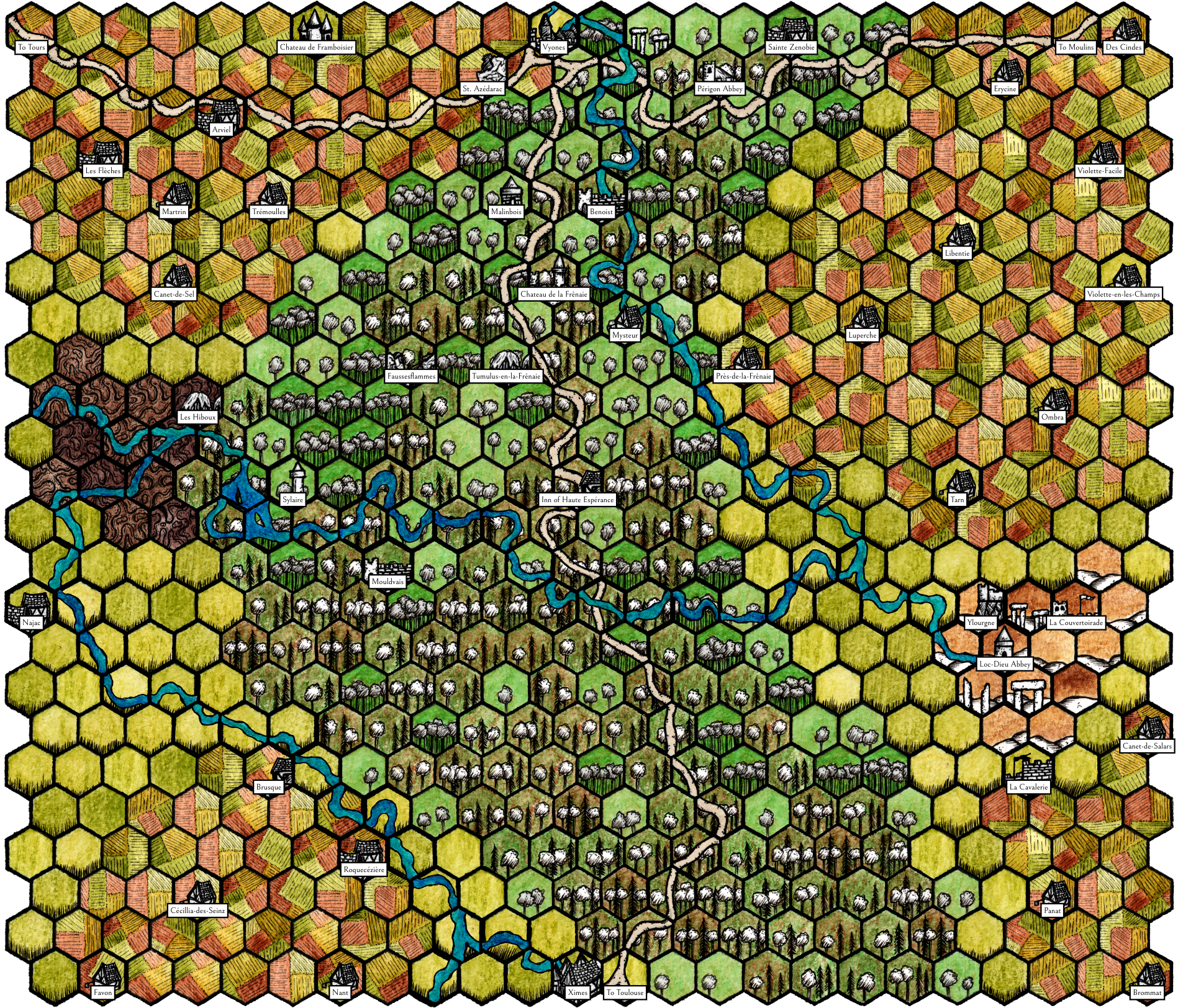
I resolved that for my Chivalry & Sorcery campaign, I would need to create my own map. A far from perfect or fully detailed thing, with many additional places not named in any of Clark Ashton Smith’s sources as best suited my purposes as a game play aid, it at least does not replicate the “errors” of the maps based on X2. Instead, all errors are my own. The map, previously glimpsed here, is presented here in full size for personal use. I created the map using Hex Kit (affiliate link).

